


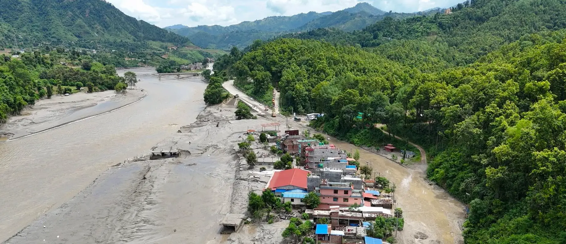

On the morning of Wednesday, August 26, 2026, a massive natural disaster struck the high Himalayas along the Nepal-China (Tibet) border. The Nepal flash flood 2026 occurred around 8:00 AM – 9:00 AM. As of August 31, 2026, the death toll has risen to 903, while over 4,200 people remain missing, according to the latest government figures.
Among the missing are over 288 Indian nationals (predominantly pilgrims) along with tourists from the US, UK, Australia, Canada, and other nations. Also, 88 + high-risk medical and tourist evacuations were carried out via military and private helicopters within 24 hours as ground passage fully collapsed. And as of evening 31 August 2026, approximately 9,000 people have been rescued according to the National Disaster Risk Reduction & Management Authority.
The disaster severely destroyed the Rasuwagadhi International Customs Checkpost, cutting vital trade between Nepal and China just before the major autumn festive season of Nepal. At least 14 major Hydropower projectssuffered physical damage (accounting for 430 MW of power-generation capacity), including Chilime, Sanjen Khola, and Trisuli facilities. Along the river, local electricity was cut off, and communications were disrupted.
What Caused the Nepal Flash Flood?
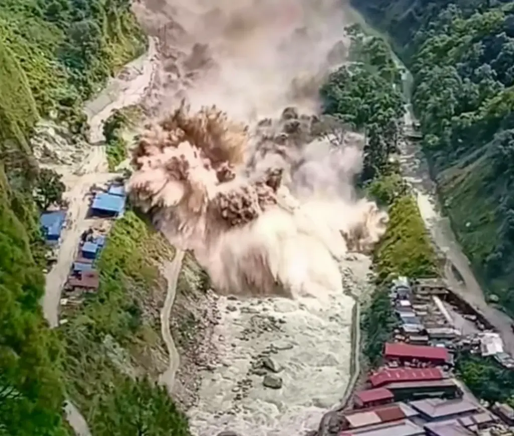
The United States Geological Survey (USGS) and satellite data by the International Centre for Integrated Mountain Development (ICIMOD) confirmed that a massive portion of a glacier (at an elevation of approximately 5,200m) detached and crashed over 1000 meters into the valley. This catastrophic glacial lake and ice-rock collapse occurred upstream in the Lhende Khola/Bhote Koshi.
Approximately two-thirds of a glacial mass, ice, and sediment detached, triggering a massive avalanche that temporarily dammed the upper Lhende drainage/river valley along the Nepal-Tibet border, before releasing a devastating outburst flood (GLOF) downstream. It caused the water level in the Trisuli River to rise by 9 meters in under 30 minutes.
Initial statements suggested a magnitude 4.4 earthquake caused the disaster. However, the USGS clarified after reviewing long-period seismic waves and Planet Labs satellite data that no earthquake occurred. The seismic shockwaves equivalent to 5.2 occurred entirely by the kinetic force of the massive glacial collapse.
How Far the Flood’s Damage Reached
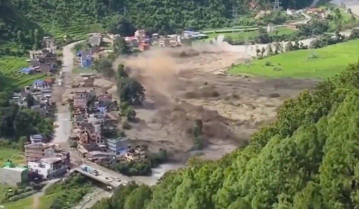
The rapid Nepal flood traveled through a 60 km (37-mile) river valley spanning the Nepal-China border. In the first 10 minutes, the wall of water surged 20km downstream through the Bhote Koshi and Trisuli rivers.
The destruction started in the Rasuwa district down through the Bhote Koshi and Trisuli . The massive destruction in the Rasuwa district affected settlements in Timure, Syaprubesi, Hakubesi, Mailung, and Rasuwagadhi border checkpoints. Then, downstream in the Nuwakot district affected Betrawati, Devighat, and Trisuli Bazar.
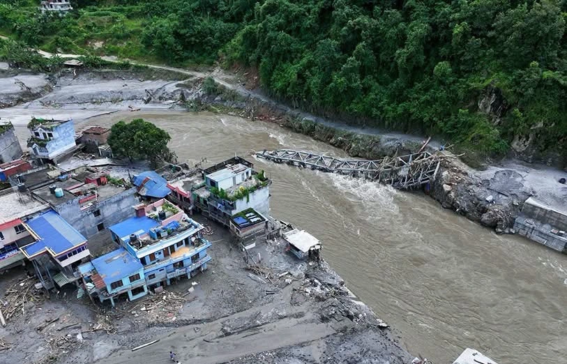
Areas in the Dhading district, like Galchhi, Galaudi and Malekhu Bazar, experienced riverbank damage. The flood joined the Marshyangdi in Mugling, Gorkha, Chitwan, and toward the Narayani/Gandal River hundreds of kilometers away.
The 42-kilometer road connecting Betrawati to the Rasuwagadhi border crossing, Nepal’s trade and pilgrimage route with Tibet, was destroyed at multiple points. Over 40 km of highways were swept away. Dozens of concrete and suspension bridges were washed out.
Nepal-Tibet Border: Pilgrims Caught Mid-Journey
The Bhote Koshi flood hit the Rasuwagadhi-Gyirong (Kerung) border, a major gateway for the sacred Kailash Mansarovar Yatra. Pilgrims and tourists were caught directly by the flood while traveling, leaving records stuck, swept away, or missing. It caught travel groups, tour buses, and border queues completely as the water level rose by meters in minutes.
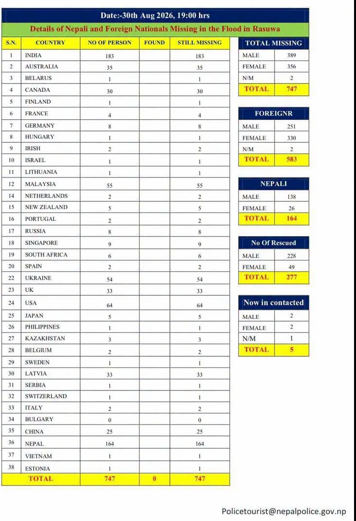
The foreign tourists and pilgrims were traveling for the annual Kailash Mansarovar Yatra, a pilgrimage to Mount Kailash and Lake Mansarovar in Tibet (China). The routes to it connected via mountain paths through Nepal’s Rasuwa district and into Tibet’s Gyirong. It is a revered site by Hindus, Buddhists, and Jains. Additionally, local pilgrims were traveling towards the high-altitude Gosainkunda Lake in Rasuwa to observe the annual Janai Purnima Festival who go stuck mid-journey.
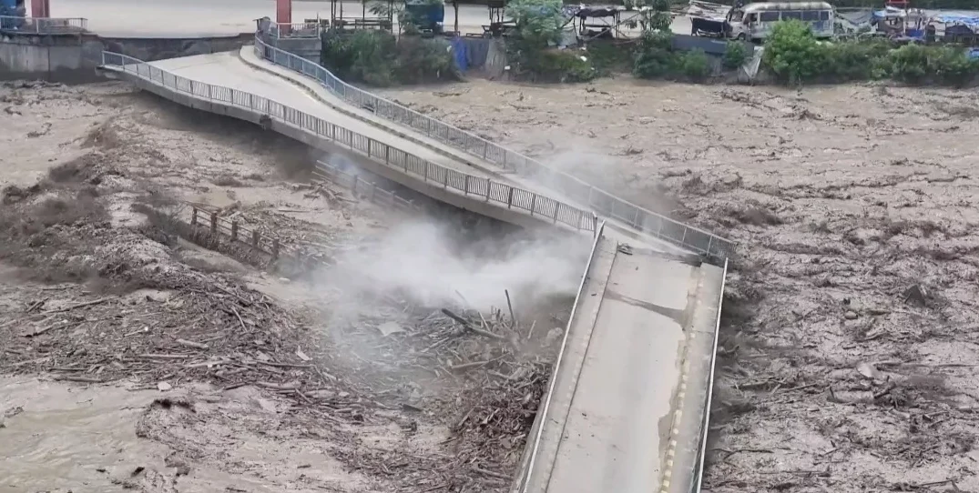
Latest Update: Is There a Risk of a Second Flood?
On the morning of August 30, 2026, authorities reported a fresh rise in the Bhote Koshi River’s flow. Officials said there is currently no indication of a major flood threat along riverbank areas of Rasuwa, Nuwakot, and Dhading.
Earlier that morning, the Flood Forecasting Division had issued a high alert after Rasuwa Police reported hearing a loud sound associated with a possible flood surge in the river, and residents along the Bhote Koshi and Trisuli rivers were urged to stay alert and move to safer ground if needed. However, in its latest update at 5:45 AM, the Flood Forecasting Division said water flow had increased slightly in Nuwakot, but the rise was not significant.
The fresh surge still caused some damage, affecting several riverside houses and washing out one suspension bridge over the Trisuli River between Dhading and Gorkha districts.
Given the situation remains fluid, trekkers and travelers heading toward the Rasuwa-Langtang region are advised to stay updated through official channels before planning their journey.
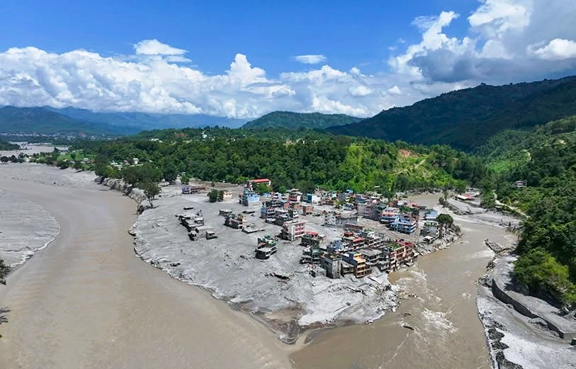
Affected Rasuwa trekking trails during the Nepal flash flood 2026
The disastrous flood severely affected the Langtang Valley Trek, Gosainkunda Pilgrimage trail, Tamang Heritage and Ruby Valley routes.
The upper Langtang Valley trail (Lama Hotel, Rimche, Thangsyap, Langtang village, and Kyangjin Gompa) suffered no damage, as the river flow started from the Lhende/ Bhote Koshi branch. However, the entrance point, Syabrubesi, and the downstream road access were damaged. The specific Janai Purnima pilgrims for August 29th faced weather challenges and were cut off from lower paths. Trailheads connecting Syabrubesi, Gatlang, Chilime, and Rubi Valley/Ganesh Himal access points via Dhading have also collapsed temporarily.
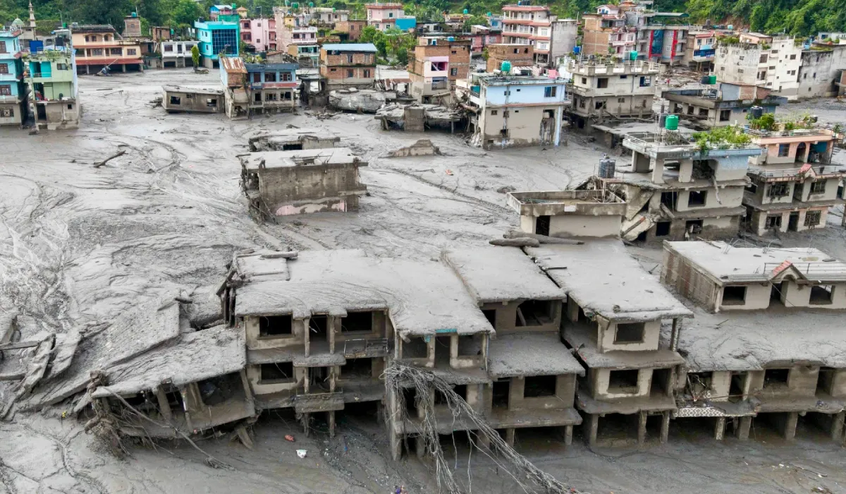
Langtang Trekking Route after Nepal Flash Flood 2026
Higher-altitude trekking routes and villages deeper into the Langtang region (like Langtang village, Kyanjing Gompa, and trails) remain safe and unharmed. However, the trailhead access points and lower valley were damaged by the flash flood. The essential base villages (Syabrubesi and Timure) and main trail of the Langtang Valley have suffered catastrophic flooding.
The gateway of the main Langtang Valley Trekking route has suffered heavy damage. Especially at Syabrubesi village riverside homes, lodges, and bridges were swept away. The village has experienced power outages and communication loss.
Note: Until flood risks are relieved and the infrastructure is reconstructed, the trailheads to the Langtang Valley Trek, Gosainkunda, and Tamang Heritage are suspended.
TAAN’s Official Safety Status: Which Trekking regions remain safe by Nepal Flash Flood 2026
Annapurna region: The Annapurna region of Nepal is one of the most popular travel destinations in Nepal and is currently safe and unaffected by the Nepal floods of 2026. Trekking in the Annapurna region, including the Annapurna Base Camp, Annapurna Circuit, Mardi Himal, and Khopra Danda treks, is famous for the magnificent views of Annapurna I, Annapurna II, Annapurna III, Annapurna IV, and Annapurna South.
Likewise, Dhaulagiri, the 7th-highest mountain in the world, along with Nilgiri, Machhapuchhre (Fishtail), and Gangapurna, are among the major attractions along the Annapurna trekking routes. According to the Nepal Tourism Board and the Trekking Agencies’ Association of Nepal (TAAN), following the devastating flash floods in Nepal, the trails and destinations in the Annapurna region are safe and open for trekking.
Everest (Khumbu) region: This is Nepal’s iconic trekking region, including Lukla, Namche Bazaar, Everest Base Camp, and Gokyo Lakes. Trekking in this region, including 14 day Everest Base Camp trek is known for breathtaking experiences through the trails along the world’s highest mountain, Mount Everest (Top of the World). The region is served by the Dudh Koshi river system, which has experienced no floods, and air transit via Lukla remains stable, keeping the region safe.
Manaslu region: The Manaslu trekking region is far from the flooding areas and rivers, and the region remains safe during the Nepal Bhote Koshi flash flood. The villages, places, and teahouses in the Manaslu trekking region are in normal condition and ready to serve trekkers.
The Manaslu region is famous for its spectacular Manaslu Circuit Trek, exploring the remote Tsum Valley, enjoying panoramic mountain views and dramatic landscapes, and experiencing the local lifestyle and culture.
Since the region remains safe from the flood, access to the area has been affected because one of the regular motorable road bridges was washed away by the Trishuli River flood on 26 August 2026. Therefore, TAAN has recommended using an alternative road to reach the trailhead for the Manaslu Circuit and Tsum Valley treks.
The recommended route is Kathmandu – Benighat – Arughat – Soti Khola / Machha Khola, avoiding Dhading Besi and the Phurke Khola Bridge, which was damaged during the flood.
Kanchenjunga region: It is in the far eastern Himalaya of Nepal, surrounding the world’s third-highest peak (Mount Kanchenjunga). The journey here, Kanchenjunga circuit trek offers a remote and off-the-beaten-path experience. The Kanchenjunga region is completely separated from the central river routes affected by floods, leaving it unaffected and safe to travel.
Makalu region: This trekking region is a rugged eastern Himalayan area that offers pristine high-altitude landscapes leading to the base of the 5th-highest mountain, Mt Makalu. It is in the Arun River valley, unaffected by the Recent Himalayan glacial outburst (flood) of Bhote Koshi river.
Rolwaling: It is a steep, isolated, and less-known valley, west of Everest. The journey highlights include Tsho Rolpa glacial Lake and challenging passes. As the region sits in the Tamakosi River Valley east of the affected zone, high-pass trails here remain safe and unharmed from the recent Nepal flash flood.
Helambu: It is just north of Kathmandu; a famous trekking region for its lush hills, Hyolmo Buddhist culture, and accessible trails, and a great alternative to Langtang treks. Trekking routes here are just opposite the flood-affected trails. Keeping the routes in the Hyolmo region dry and accessible via Sundarijal.
Dhaulagiri region: This region offers a challenging trek in western Nepal around the massive Dhaulagiri and is suited for experienced trekkers. The trekking routes here lie deep in Kali Gandaki, which is unaffected by the August flood.
Dolpa: This is a high-altitude rain-shadow region of Nepal with Tibetan culture, glacial lakes like Phoksundo, and ancient Bon monasteries. It is along the Karnali River Valley, protected by geographic distance from the flood area.
Rara and Jumla: These regions are home to Nepal’s largest lake, Rara Lake within the Rara National Park. Located in the far northwest Karnali region, it is completely disconnected from the central Himalayan rivers, leaving it unaffected by the Rasuwa flood.
Farwest (Saipal, Khaptad, Badimalika, Api Himal): All these regions have off-the-beaten-path destinations with alpine landscapes, sacred mountains, and remote western Himalayan experiences. These regions are completely clear and unaffected by the Nepal flash flood and are situated in the far-western province trails.
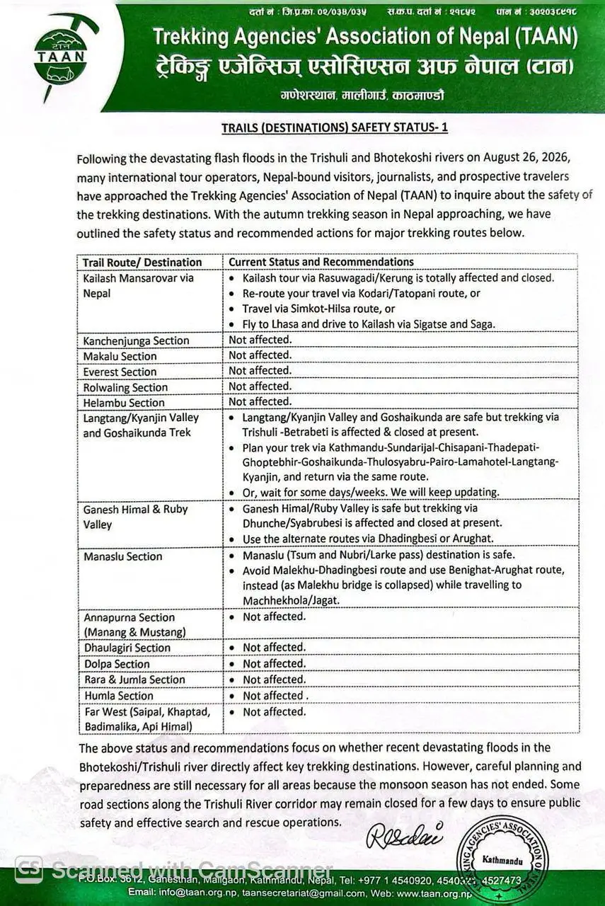
Official Alternative Trekking Routes by TAAN for the flood-affected region
Langtang/Kyanjin Valley and Gosainkunda trek: Plan your trek via Kathmandu- Sundarijal -Chisapani -Kutumsang -Thadepati – Ghoptebhir- Gosainkunda- Thulosyabru- Chisapani- Pairo- Lama Hotel- Langtang- Kyanjin, and return via the same route
Ganesh Himal and Ruby Valley: As the route from Dhunche/Syaprubesi is closed use Dhadingbesi -Borang -Chalish or Arughat -Laprak route.
Kailash Mansarovar route: Kailah tour via Tatopani / Kodari Border (via Sindhupalchok) route, travel via Simikot -Hilsa Route (Flight to Simikot, western border), or fly directly from Kathmandu to Lhasa and drive to Kailash via Sigatse and Saga.
What to do if you have an upcoming trek booked in the affected Rasuwa Langtang region?
Considering the recent Nepal Flash flood 2026 in the Rasuwa-Nepal-China border, take the following steps to manage your booking safely and effectively if you have booked a trek.
Contact your agency or hotel directly: Reach out to your local trekking agency or accommodation host. Most of the agencies are automatically postponing or offering alternative plans rather than forcing cancellations.
Choose your travel alternatives: The best option for immediate travel plans is to transfer your booking to stable trekking areas unaffected by floods, such as Annapurna Base Camp Trek, Mardi Himal Trek, Pikey Peak Trek, Everest Base Camp Trek, or Gokyo Lake Treks.
New Alternative Langtang Approach and Langtang Valley Trek (For later in Autumn)
If you are travelling later in the season (October/November), we follow modified routes that bypass lower valley trailheads and Syaprubesi for Langtang Valley Trek.
Quick Route view for Langtang Trek via Dhunche
You begin at Dhunche and climb through the forested trails toward Deurali and to Thulo Syabru. It is a high-ridge, unaffected path to the Langtang trail. Descending through the oak and rhododendron forests, you connect the main Langtang Valley Trail at Rimche, Lama Hotel, Langtang Village, Kyanjin Gompa, and return to Dhunche, completing the Langtang Valley Trek safely.
Wait for immediate cancellation for October or November. Infrastructure measurements are ongoing, and alternative ground approaches or trails may open before your trip.